Ron Laughlin explores what’s on offer for RVers on the way through the West Coast
In this article, we drive north from Hokitika to Westport and follow State Highway 67 as far north we could drive. Just a few kilometres out of Hokitika, on the left and well marked, is one of the easiest to use dump stations in the country. For those who wish to explore inland east of Hokitika and experience a little more of the region, take the road to Lake Kaniere. Here you will discover a beautiful body of water that provides a lot of water recreation for the area and for the visiting movanner, there are a couple of great parking spots.
It is a 25km drive from Hokitika north to Kumara Junction where, if you continue east, State Highway 73 takes you through Arthur’s Pass en-route to Christchurch (255km). This is a trip all of its own and is one of the most scenic routes in the South Island, but for now let us continue the dramatic route north toward Karamea.
But there are some recommended detours for explorers. Outside of Kumara Junction on State Highway 73, take the Kumara-Inchbonnie partial dirt road north out of Kumara to Lake Brunner, the largest lake on the West Coast. On the south shore of the lake are a couple of small parking spots. It’s a fabulous place to do some trout fishing or just relax in the wilderness beauty.
You can return the way you arrived or continue around the lake through the small community of Moana. From there you can circle back to Greymouth. A few kilometres north from Moana you will reach State Highway Seven where you turn left and follow the Grey River back to State Highway Six.
Greymouth, built on the Grey River, is the largest town on the West Coast. A favourite overnight spot of campers is near the mouth of the Grey River. When in town, visit the Jade Boulder Gallery (1 Guinness Street) for the ultimate in jade work and the best coffee in town. Ten kilometres south is Shantytown, a restored pioneer town based upon the West Coast gold rushes of the mid-1800s. It is more than just a tourist trap and is well worth a look around.
Behind the Caltex station on Tainui Street is a place for showers and washing/drying as well as a dumpsite.
Two kilometres north of Greymouth over the bridge, turn left past Cobden just past Jellystone Park for a great spot to overnight on the ocean and one of the best locations to experience a West Coast sunset. It’s 102km from Greymouth to Westport along world-class scenic views. Worth a stop is the Punakaiki Pancake Rocks, 46km from from Greymouth. Usually full of tourists, this isn’t one to miss and there are plenty of parking spaces.
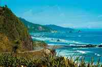
The next portion of the coastline is our favourite in New Zealand. You twist and turn along the coastal highway as the scenery provides confirmation of New Zealand as a wild and wonderful place. There are plenty of parking spots and photo opportunities along the route. We enjoy stopping at the Punakaiki Canoes just north of the Pancake Rocks to chat with the owners.
You will be surprised at the quality of the local artwork by the owner/artist and he can even make a good espresso. Over the bridge you can also stop for the night. There is also a nice stayover at the Punakaiki Holiday Park with a great pub in walking distance.
At Westport, State Highway Six joins with State Highway 67. Six kilometres from the start of State Highway 67, take a left on State Highway 67A to Cape Foulwind. A walk up the hill to the lighthouse provides you with the scenery Captain Cook must have witnessed as he passed by.
You might want to visit the seal colony also when out there. The town of Westport is 11km to the north. Be sure to stop by the information centre in the centre of the town on Brougham Street. For a freedom campsite right on the beach, continue on Brougham Street. Four streets on the left after the information cerntre (Derby Street) turn left and go to the edge of town, turning left on Coates Street.
You can go out to the mouth of the Buller River from here but just before you pull up on the causeway there is a dirt road to the right that will take you to a well-kept private open area just for freedom camping.
Have fun!
Two interesting places to visit in Westport are the Miners Brewing Company (Lyndhurst St) and the Coaltown Museum on Queen Street. There is a dump station at the Fresh Choice grocery at the corner of Fonblanque and Russels Streets. The store is also the best place to pick up essentials in Westport.
Now it is off north toward Karamea. This is one of our favourite regions in the country north of Westport. We recommend a side drive up to Denniston. Turn off to the right at Waimangaroa on well sign posted roads.
The Denniston Rose, written by Jenny Pattrick, is your introduction to Denniston and perhaps the West Coast of New Zealand, and is rumored to soon be a movie. It is the story of a pioneering mother and daughter struggling in 1880s in Denniston and reveals how life must have been in those early pioneer days. One of the best books we have ever read and there is a sequel!
You can take your vehicle on a good road up to the top of the mountain of coal, 600m above sea level. The view from the top is very dramatic. The building of the incline to bring the coal down was one of the world’s greatest engineering feats. From 1880 to 1967, 12 and half million tonnes of coal were brought down an incline so steep it seems unbelievable, even today. Be sure to go on the side road that takes you to the bottom of the incline to see some of the items still remaining. What a history!
Returning to State Highway Six at Waimangaroa, directly across the road there is a dirt road beside the pub that leads to the beach. It’s a great spot to spend the night and an opportunity to walk around the old graveyard close by where many of the early residents of Denniston were buried. They couldn’t be buried on the mountain, the ground was too hard. Many residents never came down from there except to be buried.
Continuing north of Westport, along 28km, you will come to the small town of Granity. Two good places to stop in the town are Steve Terry’s “Drifter’s Cafe” in the centre on the right, and on the ocean side going north out of town is “The Big Fish”. Be sure to stop and say hello to Kevin and Pauline.
You are welcome to stay the night there if you are an NZMCA member since it is a POP. Continuing north on State Highway 67 you pass through the town of Hector. There is a country/western music museum worth stopping to see if that’s your thing. There’s an amazing collection of music and photos.
The next stop we recommend is on the north side of the Mokihinui River on the left. A narrow dirt road takes you to Gentle Annie’s Campground. There’s no electricity (showers are good though) to the campsites, but it’s one of the best locations where river, ocean and bush join. They also have the Cowshed Cafe on site. It’s definitely off the beaten path. You’ll love it!
 From here, it is a 70km drive north to Karamea and the end of the road at the Kohaihai Bluff. This is the location of the south end of the Heaphy Track.
One of the most exciting meetings of river and ocean punctuate the beauty of the DOC camp on the Karamea River. If you enjoy tramping, you may wish to take the trip through the Kahurangi National Park to Golden Bay via the Heaphy Track or maybe take a short excursion along the path while you are there.
This completes the entire drive of the West Coast from Haast to Karamea, one of the most exciting drives in the world. Take your time to stop and see as much as you can and have a yarn with the locals. It’s a great place, there are great people and it’s a wonderful experience for everyone on the road. The over 500km of the West Coast are truly a real movanning adventure.
Photos by Ron Laughlin


loveablenana - 12 years ago
A very interesting must read article. Thankyou for sharing.