


Extracted from The Greatest Walks of the World by Stuart Butler & Mary Caperton Morton, published by Exisle, RRP: $49.99.
Location:
Tasman National Park,
Tasmania, Australia
Duration:
4 days
Difficulty:
Moderate
Distance:
28.5 miles (46 km)
Map:
Hema Tasmania State Map
Start/End:
Port Arthur/Fortescue Bay
Trailmarking:
Signs
Hike to the ends of the Earth on the ragged edge of Tasmania.
Curiously, there are only two capes along Australia’s famous Three Capes Track: Cape Pillar and Cape Hauy. To hike the third, you’ll need to tack on an 8.7-mile (14 km) out-and-back day hike to the tip of Cape Raoul, west of Port Arthur, best done as a warm-up before tackling the other two capes on your four-day hut-to-hut trip. But even if you skip the day hike and only visit the two capes, you won’t feel short-changed on this gorgeous multiday hike along the Tasmanian coast. Between the colorful stands of eucalyptus trees and stunning views of the Tasman Sea along the narrow, clifftop peninsulas, there are many reasons that this is one of Australia’s most popular treks.
Devils and Tigers
The island of Tasmania, located 150 miles (241 km) south of the mainland, was separated from Australia by rising sea levels around 11,700 years ago. The Bass Strait has presented a formidable barrier to animal and plant migration for at least that long, resulting in a unique assemblage of flora and fauna on the island. The most famous endemic residents of Tasmania are the Tasmanian devil, a small carnivorous marsupial, and the Tasmanian tiger, or thylacine, which was declared extinct by the Tasmanian government in 1986. The last thylacine was shot in the wild in 1938, but rumors and unconfirmed sightings of the doglike tiger-striped marsupial persist to the present day.
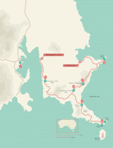 The Route
The Three Capes Track begins at Port Arthur, once a penal colony, now a historic site, where you’ll catch a boat across the bay of Port Arthur to Denmans Cove. From there you’ll trek for four days, stopping each night at modern huts, so you don’t need to carry a tent or cooking equipment. The four-day walk visits Cape Pillar, Cape Hauy, Mount Fortescue, Arthurs Peak, and the Ellarwey Valley, and ends at Fortescue Bay.
1. PORT ARTHUR
Port Arthur is a beautiful place with a notorious past. Located 60 miles (97 km) southeast of the state capital Hobart, Port Arthur operated as a large penal colony from the 1830s until 1877.
Touted as an inescapable prison, the peninsula on which Port Arthur sits is a natural fortress, surrounded by water. The only connection to the Tasmanian mainland is via a 100-foot-wide (30m) isthmus called Eaglehawk Neck. Today the penal colony is preserved as the Port Arthur Historic Site.
2. CAPE PILLAR
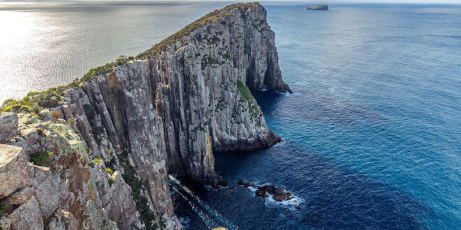
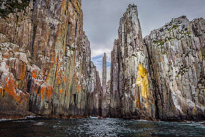
The southeasternmost point of the island of Tasmania is a long, narrow strip of land that juts out into the Tasman Sea. This cape is named for its distinctive pillars of Jurassic-era dolerite, a type
of volcanic rock that forms the tallest sea cliffs in Australia, soaring 980 feet (299 m) high above the waves. As you approach the needlelike end of the cape, the towering columns of dolerite narrow to a dramatic, crumbling knife-edge called the Blade. Offshore sits the oval-shaped cliff-bound Tasman Island, home of the Tasman Island Lighthouse, truly the ends of the Earth.
3. OVERNIGHT HUTS
On the Three Capes Track you can choose to carry a tent and camp in designated campsites or book beds in the three backcountry huts—Surveyors Cove, Munro, and Retakunna Creek—
along the way. Each hut has running water, gas top stoves, sleeping cots, and toilets, as well as modern amenities like USB charging stations, yoga mats, and memory foam mattresses. The huts sleep four to eight people so tenting will likely be a quieter option.
4. CAPE HAUY
The second cape of the Three Capes Track isn’t as dramatically narrow as Cape Pillar, but the views of the rocky coastline and the sea beyond on both sides of the cape are just as spectacular. You’ll descend a series of steps toward the end of the cape, which is also lined by towering dolerite columns that plunge straight down into the sea. Be careful of the cliff edges as it’s often windy here. You might consider carrying binoculars on your trek as this is an epic spot to watch for humpback whales, seals, seabirds, and the endangered Tasmanian wedge-tailed eagle.
5. MOUNT FORTISCUE
The high point of this hike comes on day three, with a climb up 1,608-foot (490 m) Mount Fortescue. The trail up the mountain runs through mossy, fern-filled eucalyptus forest. Keep an eye out for the elusive Tasmanian short-beaked echidna, a spiny-backed insect-eating mammal that lays eggs. From the summit, through thick vegetation, you’ll be able to see Cape Pillar, Cape Hauy, Fortescue Bay, and the rest of the trek.
Walk here next
These scenic cape treks combine rugged terrain with dramatic, steep cliffs, native bush, and spectacular coastal views of crystal clear waters.
Tag the third cape
CAPE RAOUL
The third cape of the Three Capes Track, Cape Raoul, is located west of Port Arthur, whereas the rest of the Three Capes Track is on the east side of the bay. This hike to the southernmost tip of the Tasman Peninsula is best done as a day hike before you undertake the four-day Three Capes Track. The 8.7-mile (14 km) out-and-back trail is well-maintained by the park but requires 4,400 feet (1,341 m) of elevation gain, mainly on the tip of the peninsula, which is paved with many stairs to negotiate the rugged clifftop route, and on the way back to Port Arthur. Like Cape Pillar and Cape Hauy, Cape Raoul is lined with dramatic dolerite columns that have been eroded to a point by the crashing waves of the Tasman Sea.
A challenging hike through dramatic coastal scenery
CAPE BRETT TRACK
Can’t get enough of cape treks? Set out for this 18.8-mile (30.2 km) round-trip adventure to the top of the long, narrow Cape Brett, near the tip of New Zealand’s North Island. At the very end you’ll find the Cape Brett hut, with stellar views of the Cape Brett Lighthouse and the aptly named Bay of Islands. Pack a swimsuit and beach towel for the hour-long side trip to Deep Water Cove, where you’ll find a picturesque sandy beach.

Join the Discussion
Type out your comment here:
You must be logged in to post a comment.